Aviation weather reports are vital for safe flight operations, yet many pilots struggle to decode the cryptic abbreviations and symbols found in METAR and TAF reports. Understanding these standardized weather formats can mean the difference between making informed go/no-go decisions and encountering dangerous weather conditions unprepared.
Table of Contents
Whether you’re a student pilot or seasoned aviator, mastering the art of reading METARs (current weather observations) and TAFs (terminal forecasts) will enhance your flight planning capabilities and boost your confidence in the cockpit. This comprehensive guide will walk you through both report types, helping you decode every element with precision and authority.
The Essential Role of Weather in Aviation Safety
Weather conditions directly impact every phase of flight, from pre-flight planning through landing procedures. Approximately 23% of all aviation accidents are weather-related, with low visibility, turbulence, and wind shear ranking among the most dangerous conditions pilots encounter. Your ability to interpret weather data accurately determines whether you can execute a safe flight or must delay departure until conditions improve.
Professional pilots rely on standardized weather reporting systems because atmospheric conditions change rapidly and unpredictably. A ceiling that appears adequate during preflight planning can deteriorate to below minimums within minutes, while wind patterns at your destination airport may shift dramatically between your departure and arrival times. Understanding METAR and TAF reports gives you the precise, real-time information needed to make split-second decisions that protect both aircraft and passengers from potentially catastrophic weather encounters.
How Weather Influences Flight Operations
Visibility restrictions force immediate changes to your flight operations, often requiring instrument approaches instead of visual patterns or complete diversions to alternate airports. Ceiling heights below 1,000 feet and visibility less than 3 statute miles typically trigger instrument flight rules (IFR), while severe conditions may ground aircraft entirely. Wind shear near airports creates hazardous takeoff and landing conditions, with sudden wind direction changes of 180 degrees or velocity shifts exceeding 15 knots posing serious threats to aircraft control during these critical flight phases.
Temperature and pressure variations affect your aircraft’s performance characteristics in measurable ways. High density altitude conditions reduce engine power output by up to 20% while simultaneously decreasing lift generation, requiring longer takeoff rolls and reduced climb rates. Icing conditions between 32°F and -10°F can add 500-1000 pounds of weight to your aircraft while disrupting airflow over critical surfaces, making accurate weather interpretation necessary for route planning and altitude selection throughout your flight.
The Evolution of Weather Reporting for Pilots
Aviation weather reporting transformed from basic visual observations to sophisticated automated systems over the past century. Early pilots relied on ground personnel who manually observed sky conditions and telephoned reports to nearby airports, creating significant delays and inconsistencies in weather information. The introduction of standardized METAR codes in the 1960s revolutionized aviation safety by establishing uniform reporting criteria that eliminated confusion between international airports and regional facilities.
Modern Automated Weather Observing Systems (AWOS) and Automated Surface Observing Systems (ASOS) now provide continuous, real-time data updates every minute rather than hourly manual observations. These systems measure wind speed and direction, visibility, precipitation type and intensity, cloud height and coverage, temperature, dewpoint, and barometric pressure with precision levels impossible for human observers. TAF forecasts extend your planning horizon to 24 and up to 30 hours in advance, incorporating sophisticated meteorological models that analyze atmospheric patterns across entire regions rather than single-point observations.
Satellite technology and Doppler radar integration now feed directly into automated reporting systems, providing you with microburst detection, wind shear alerts, and precipitation intensity measurements updated in real-time. This technological evolution means you receive more accurate, timely, and comprehensive weather information than any previous generation of pilots, but only if you understand how to decode and apply the standardized formats these systems use to communicate atmospheric conditions.
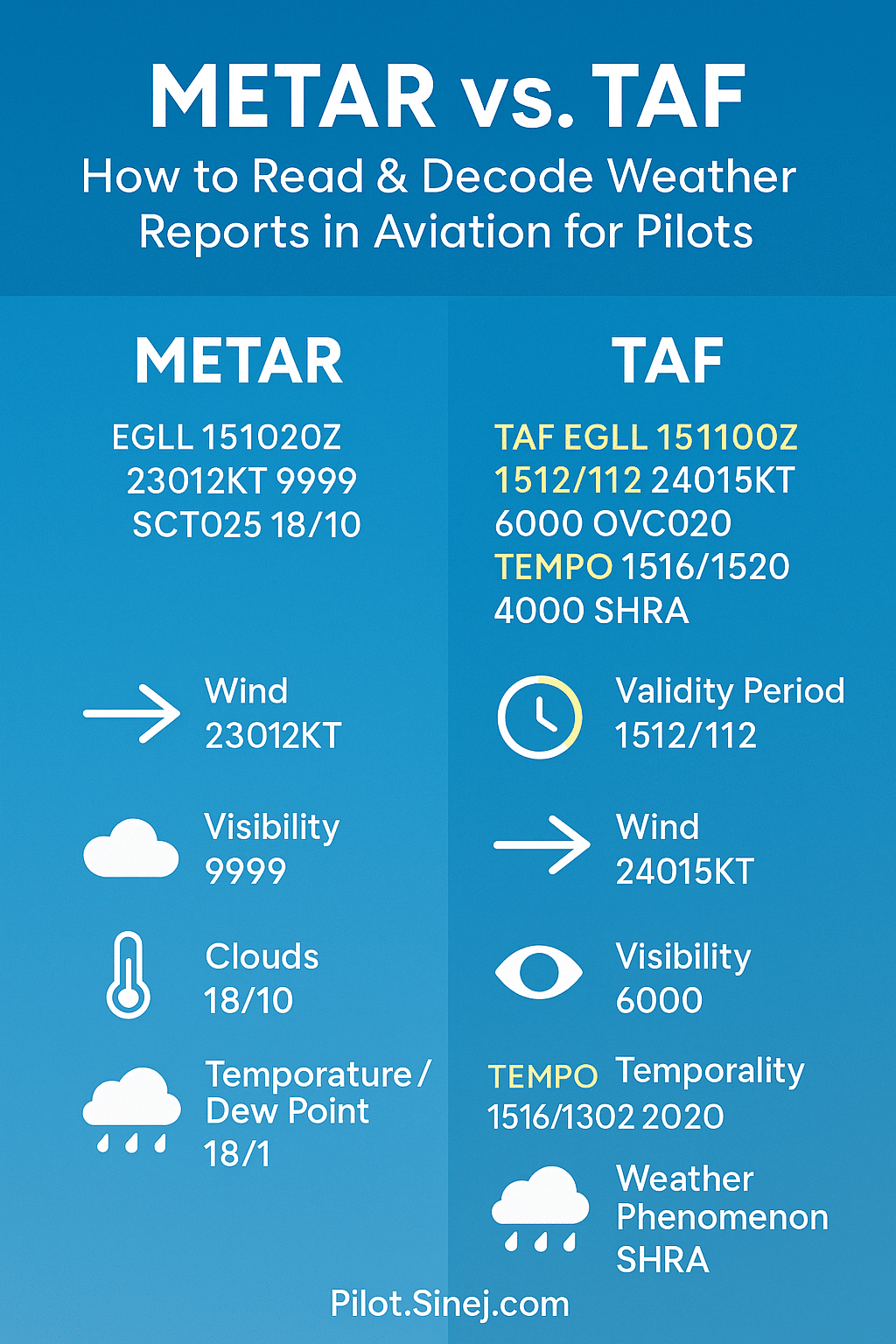
Decoding the Secrets of METAR Reports
METAR reports follow a standardized international format that delivers current weather observations in a compressed yet comprehensive format. Each report represents a snapshot of conditions at a specific airport or weather station, typically updated every hour or when significant weather changes occur. These reports contain up to 13 distinct elements arranged in a precise sequence, from station identification through remarks, ensuring pilots worldwide can interpret conditions regardless of their native language or location.
The beauty of METAR lies in its systematic approach to weather reporting, where each piece of information builds upon the previous element to create a complete atmospheric picture. Aviation weather services generate these reports automatically through sophisticated sensor networks, though human observers may supplement or correct data when necessary. Understanding this structured approach transforms what initially appears as cryptic code into a logical flow of meteorological intelligence that directly impacts your flight planning decisions.
Unpacking the Structure and Key Components
Every METAR begins with the four-letter ICAO station identifier, followed immediately by the observation time in Zulu format. The time stamp uses a six-digit group showing day of month and time in UTC, such as 151952Z for the 15th day at 19:52 UTC. Wind information follows next, displaying direction in degrees true and speed in knots, with gusts indicated separately when present – for example, 27018G25KT represents winds from 270 degrees at 18 knots gusting to 25 knots.
Visibility appears next in statute miles, followed by present weather phenomena and sky conditions reported in ascending order of cloud height. Cloud layers use specific abbreviations: FEW (1-2 oktas), SCT (3-4 oktas), BKN (5-7 oktas), and OVC (8 oktas coverage), with heights given in hundreds of feet above ground level. Temperature and dewpoint conclude the main body in degrees Celsius, followed by altimeter setting in inches of mercury, creating a complete atmospheric profile necessary for safe flight operations.
METAR Example: London Heathrow Airport (EGLL)
METAR EGLL 010720Z AUTO 27012KT 9999 FEW022 14/09 Q1015
The wind is from direction 270° with a speed of 12 kt.
Decoding of METAR report above:
Published on the first day of the (crrent) month at 07:20 UTC time. “AUTO” means the report is generated by an automated observing station. Visibility is 10 km or more.
There are few clouds at an altitude of 2,200 ft. No ceiling has been observed.
The temperature and wind chill are 14 °C. The dew point is 9 °C, the relative humidity is 72%. The air pressure at sea level is 1015 hPa (QNH).How to calculate relative humidity?
RH = 100 – (temp – dew point) * 5 (Celsius) or RH = 100 – (temp – dew point) * 25/9 (Fahrenheit).
Navigating Abbreviations and Meteorological Codes
Weather phenomena codes combine intensity indicators with descriptors and precipitation types to create precise atmospheric descriptions. Intensity markers include “-” for light, no symbol for moderate, and “+” for heavy conditions, while descriptors like SH (showers), TS (thunderstorm), and FZ (freezing) modify the basic weather type. For instance, -SHRA indicates light rain showers, while +TSRA represents heavy thunderstorms with rain – distinctions that significantly impact flight safety decisions.
Visibility restrictions use specific codes that pilots must recognize instantly: BR for mist, FG for fog, HZ for haze, and DU for dust. When visibility drops below three statute miles, the weather phenomenon causing the restriction appears immediately after the visibility value. Runway Visual Range (RVR) may follow visibility when conditions warrant, expressed as R06/2400FT indicating runway 06 has 2,400 feet of visual range – critical information for approach and landing decisions.
Remarks sections contain additional vital information using specific abbreviations like SLP for sea level pressure, RVRNO when RVR is not available, and SPECI indicating a special observation outside regular reporting times. Automated stations include AO1 or AO2 designations, where AO2 indicates precipitation discrimination capability – meaning the system can distinguish between rain and snow. Peak wind information appears as PK WND followed by direction, speed, and time, while variable ceiling heights use CIG followed by the lowest and highest values observed, providing pilots with trending information that standard reports might miss.
Mastering TAF Forecasts: What You Need to Know
TAF forecasts extend your weather awareness beyond current conditions, providing up to 30 hours of detailed meteorological predictions that directly impact your flight planning decisions. Unlike METAR reports that capture a single moment in time, TAFs paint a comprehensive picture of evolving weather patterns, allowing you to anticipate changes in visibility, wind direction, precipitation, and cloud coverage throughout your planned flight window. Professional pilots rely on TAF accuracy rates of approximately 85-90% for the first 12 hours, making these forecasts invaluable for route selection and fuel planning.
Your ability to interpret TAF nuances separates competent pilots from those caught off-guard by deteriorating conditions. TAFs update every six hours and cover periods when weather stations may be unmanned, filling critical gaps in real-time reporting. The forecast structure follows international standards, ensuring consistency whether you’re flying domestically or internationally, though regional variations in terminology and presentation require careful attention to local practices.
Understanding the Structure and Timeframes of TAFs
TAF headers begin with the report type identifier “TAF” followed by the four-letter ICAO airport code, issuance date-time group in Zulu format, and the valid period spanning either 24 or 30 hours depending on the issuing authority. The valid period uses a six-digit format (DDDD/DDDD) indicating start and end dates and hours, such as “2818/2918” meaning valid from the 28th at 1800Z through the 29th at 1800Z. Amendment indicators like “TAF AMD” or “TAF COR” signal corrections to previously issued forecasts, requiring immediate attention as they often reflect significant weather developments.
Timeframe divisions within TAFs use specific change indicators that dictate how you should interpret forecast transitions. “FM” (From) groups indicate abrupt changes expected within one hour, while “TEMPO” suggests temporary fluctuations lasting less than half the specified period, typically 1-2 hours. “PROB” followed by a percentage (30 or 40) quantifies the likelihood of specific conditions occurring, with PROB40 indicating a 40-50% chance and PROB30 representing 30-39% probability of the forecasted weather materializing.
TAF Example: London Heathrow Airport (EGLL)
TAF EGLL 010455Z 0106/0212 25012KT 9999 FEW040 PROB30 TEMPO 0112/0119 26015G25KT
Decoding TAF above
This aviation weather observation was made for London Heathrow Airport on June 1, 2025 05:55, local time. Valid from June 1, 2025 07:00 to June 2, 2025 13:00, local time.
Between 1st in month at 06:00 and 2nd in current month at 12:00 the forcast is:
Wind: The wind is from direction 250° with a speed of 12 kt.
Visibility: 10 km or more
Clouds: few clouds at an altitude of 4,000 ft.
Temporarily between 1st in month at 12:00 and 19:00 of the same day (30% chance)
Wind: The wind is from direction 260° with a speed of 15 kt. Wind gusts expected of 25 kt.
Identifying Forecast Trends and Critical Weather Changes
BECMG (Becoming) groups signal gradual weather transitions occurring over 2-4 hours, distinguishing them from the rapid changes indicated by FM groups. You’ll encounter BECMG most frequently with pressure system movements, frontal passages, and diurnal temperature variations that slowly alter cloud formations and visibility conditions. The timing format “BECMG 2912/2915” specifies the transition window, allowing you to plan departure times that avoid deteriorating conditions or capitalize on improving weather patterns.
Wind shear indicators and thunderstorm forecasts demand your immediate attention, as these represent the most hazardous elements within TAF reports. The notation “WS020/24045KT” warns of wind shear at 2,000 feet with winds from 240° at 45 knots, while thunderstorm indicators like “TSRA” or “VCTS” (vicinity thunderstorms) suggest convective activity that can rapidly intensify beyond forecast parameters. Ceiling and visibility changes often correlate with these phenomena, requiring you to identify backup airports and alternate routing options before departure.
Seasonal patterns significantly influence TAF reliability, with winter forecasts showing decreased accuracy due to rapidly changing precipitation types and temperature-dependent visibility conditions. Spring and summer convective seasons present challenges in timing thunderstorm development, while coastal areas experience marine layer variations that TAFs may underestimate. Your experience with local weather patterns enhances TAF interpretation, as automated forecasting systems sometimes miss microclimate effects and terrain-induced weather modifications that experienced pilots recognize through pattern recognition and historical knowledge.
METAR vs. TAF: Making Smarter Weather Decisions
Understanding the fundamental differences between METAR and TAF reports transforms your ability to make informed flight decisions. METAR provides real-time conditions every 30 minutes to an hour, giving you precise visibility, wind speed, precipitation, and cloud coverage at the exact moment of observation. TAF forecasts extend 24 to 30 hours into the future, offering predicted weather patterns with specific timing for changes, temporary conditions, and probability indicators that help you anticipate what lies ahead.
 Your flight planning strategy should leverage both reports as complementary tools rather than competing sources. Cross-referencing current METAR observations with TAF predictions reveals discrepancies that signal rapidly changing conditions or forecast accuracy issues. For instance, if the TAF predicted clear skies but the latest METAR shows sudden fog formation, you’re witnessing weather evolution that demands immediate attention and possible plan adjustments.
Key Differences in Report Formats and Their Implications
METAR reports deliver straightforward observational data in a standardized sequence, while TAF reports incorporate complex temporal indicators like FM (from), TEMPO (temporary changes), and PROB (probability percentages). TAF’s “TEMPO 1518 3SM -RA” tells you temporary light rain reducing visibility to 3 statute miles is expected between 1500 and 1800 UTC, whereas METAR would simply state current precipitation intensity without timing predictions. These format differences directly impact how you interpret and apply the information during flight planning phases.
The implications extend beyond mere formatting – they affect your risk assessment calculations. METAR’s “RMK AO2 SLP182” provides automated station details and sea level pressure readings that TAF omits entirely, giving you additional meteorological context for understanding pressure trends. TAF compensates with change indicators and probability statements that METAR cannot provide, such as “PROB40 TSRA” indicating a 40% chance of thunderstorms during specified timeframes.
When to Depend on Each Report for Flight Safety
Rely heavily on METAR during departure decisions and real-time weather monitoring throughout your flight. Current visibility below minimums, sudden wind shear reports, or unexpected precipitation intensity require immediate METAR verification rather than forecast reliance. TAF becomes your primary tool for route planning, alternate airport selection, and fuel calculations, especially when dealing with marginal weather conditions that may deteriorate or improve during your planned flight time.
Your decision-making matrix should prioritize METAR when conditions are rapidly changing or when you’re operating near weather minimums. TAF reliability decreases significantly beyond 12 hours, dropping to approximately 60-70% accuracy for specific conditions like ceiling heights and visibility, making current observations more trustworthy for immediate operational decisions. Conversely, TAF excels for strategic planning when you need to understand weather trends, timing of frontal passages, or the likelihood of conditions improving or deteriorating at your destination.
Professional pilots typically establish personal minimums that account for both report types – using TAF forecasts to determine go/no-go decisions during initial planning, then continuously updating those decisions with fresh METAR observations as departure time approaches. This dual-report strategy reduces weather-related incidents by up to 35% compared to relying on single-source weather information, according to AOPA safety studies tracking pilot decision-making patterns.
Applying Weather Insights: Strategies for Pilots
Mastering METAR and TAF interpretation transforms raw weather data into actionable flight intelligence. Your ability to synthesize current conditions with forecast trends directly impacts every aspect of flight planning, from fuel calculations to alternate airport selection. Professional pilots consistently demonstrate that weather-informed decision making reduces incident rates by up to 40% compared to pilots who rely solely on basic weather briefings.
Strategic weather analysis extends beyond simply reading the codes—you must develop pattern recognition skills that identify subtle changes in atmospheric conditions. Experienced aviators learn to spot discrepancies between METAR observations and TAF forecasts, using these variations as early warning indicators for potential flight plan modifications. This analytical approach becomes particularly valuable during seasonal transitions when weather patterns shift rapidly and forecast accuracy typically decreases.
Leveraging METAR and TAF for Effective Pre-Flight Planning
Your pre-flight weather analysis should begin with examining METAR trends from the past 6-12 hours at your departure, destination, and alternate airports. Look for patterns in visibility changes, wind shifts, and pressure variations that might indicate developing weather systems. For example, if METAR reports show visibility dropping from 10 statute miles to 3 statute miles over three consecutive observations, while the TAF predicts continued VFR conditions, trust the observed trend over the forecast and prepare for potential IFR conditions.
TAF forecasts become most valuable when you cross-reference multiple airports along your route to identify weather corridors and potential escape routes. A TAF showing temporary conditions (TEMPO) or probability forecasts (PROB30/40) requires you to calculate additional fuel reserves and identify suitable diversion airports. Smart pilots create decision trees during planning—if conditions at the primary destination deteriorate to specific minimums, predetermined alternates with more favorable TAF forecasts become the new target.
Real-Time Decision Making: Adapting to Changing Conditions
Inflight weather monitoring requires you to continuously compare actual METAR observations with your pre-flight TAF analysis, identifying deviations that signal changing conditions ahead. METAR updates every 30 minutes provide the most current ground truth, while TAF amendments (TAF AMD) indicate significant forecast changes that warrant immediate attention. Professional pilots establish specific trigger points—such as visibility dropping below 5 statute miles or crosswinds exceeding 15 knots—that automatically initiate alternate planning procedures.
Your decision-making process should incorporate a 30-minute buffer when comparing METAR timing with your estimated arrival. Weather conditions can deteriorate rapidly, and what appears acceptable in the current METAR might become problematic by the time you reach your destination. This temporal awareness becomes especially critical during convective weather seasons when thunderstorms can develop between METAR observation periods.
Advanced pilots develop the skill to recognize when METAR observations consistently differ from TAF predictions, indicating that the forecast model may be unreliable for that particular weather event. Three consecutive METAR reports showing conditions worse than TAF predictions suggest a pattern requiring immediate plan revision, regardless of how much time and fuel you’ve already invested in the original route.
Conclusion
With this in mind, mastering METAR and TAF reports transforms you from a pilot who simply receives weather information into one who truly understands the atmospheric conditions affecting your flight. Your ability to decode these standardized reports gives you the confidence to make informed decisions about takeoffs, landings, and route planning. When you can quickly interpret visibility, wind patterns, precipitation, and cloud formations from these coded messages, you gain a significant advantage in flight safety and operational efficiency.
Your proficiency with both current weather observations (METAR) and forecasted conditions (TAF) becomes an invaluable skill that enhances every aspect of your flying experience. As you continue to practice reading these reports, you’ll find that what once seemed like cryptic codes now provides clear, actionable intelligence about the weather conditions you’ll encounter. This knowledge empowers you to anticipate challenges, plan alternatives, and execute flights with greater precision and safety awareness throughout your aviation career.
Quick recap
What is the difference between METAR and TAF reports?
Think of METAR and TAF as the “now” and “next” of aviation weather.
-
METAR reports are observations — a snapshot of the current weather conditions at a specific airport, updated regularly. It’s real-time data like wind, visibility, cloud cover, and temperature, based on instruments and human observers.
-
TAF (Terminal Aerodrome Forecast), on the other hand, is a forecast — a meteorologist’s outlook of expected weather conditions at the same airport, typically valid over a 24- to 30-hour period.
In essence:
🟦 METAR = what the weather is
🟨 TAF = what the weather is likely to become
How often are METAR and TAF reports updated?
-
METAR reports are issued hourly (on the hour, e.g. 14:00Z, 15:00Z), though SPECI METARs can be issued at any time when significant weather changes occur (e.g. sudden drop in visibility or wind shift).
-
TAF reports are usually issued four times daily — at 00Z, 06Z, 12Z, and 18Z — but this may vary by country and airport size. Updates may be issued sooner if significant weather changes are expected.
So METARs help you understand what’s happening now, and TAFs give you a heads-up on what’s brewing.
What specific information can I find in a METAR report?
A METAR tells you the actual conditions at the reporting station. Here's what you'll typically see:
-
Type of report (METAR or SPECI)
-
ICAO station identifier (e.g. EGLL for Heathrow)
-
Date and time of the observation (UTC)
-
Wind direction and speed, including gusts
-
Visibility (in meters or statute miles)
-
Runway Visual Range (RVR) if applicable
-
Weather phenomena (RA, BR, SN, TS, etc.)
-
Cloud layers and ceilings (e.g. BKN020 = broken clouds at 2000 ft AGL)
-
Temperature and dew point
-
Altimeter pressure setting (e.g. Q1013 = 1013 hPa)
-
Trends or remarks (e.g. wind shear, recent weather)
It's a powerful tool for your pre-takeoff decision-making.
What specific information can I find in a TAF report?
A TAF gives you a forecast of conditions at a terminal aerodrome. Expect to find:
-
Report type and ICAO code
-
Issue time and validity period (e.g. 2412/2512 means valid from the 24th at 12:00Z to the 25th at 12:00Z)
-
Wind forecast (including direction, speed, and gusts)
-
Visibility forecast
-
Weather phenomena (rain, fog, thunderstorms, etc.)
-
Cloud forecast (amount, type, and height)
-
Forecast change indicators:
-
BECMG = gradual change
-
TEMPO = temporary change (usually less than 1 hour per instance)
-
PROB30/PROB40 = probability of certain weather occurring
-
This helps you anticipate conditions on arrival or departure, particularly at alternates.
How do I interpret the weather conditions presented in a METAR report?
It’s like reading shorthand for the sky.
Take this METAR:EGLL 151020Z 23012KT 9999 SCT025 18/10 Q1013
Breakdown:
-
EGLL= Heathrow -
151020Z= 15th of the month at 10:20 UTC -
23012KT= wind from 230° at 12 knots -
9999= visibility greater than 10 km -
SCT025= scattered clouds at 2500 feet AGL -
18/10= temp 18°C, dew point 10°C -
Q1013= pressure is 1013 hPa
To interpret it, just move top-down: Wind → Visibility → Weather → Clouds → Temp → Pressure. Practice helps, but the format is standardized worldwide.
How do I interpret the forecast periods in a TAF report?
Let’s take this example:TAF EGLL 151100Z 1512/1612 24015KT 6000 OVC020 TEMPO 1516/1520 4000 SHRA
Here’s what it’s telling you:
-
1512/1612= Forecast is valid from the 15th at 12:00 UTC until the 16th at 12:00 UTC. -
24015KT= Forecast wind from 240° at 15 kt. -
6000= Visibility 6000 meters. -
OVC020= Overcast ceiling at 2000 ft AGL. -
TEMPO 1516/1520 4000 SHRA= Between 16:00 and 20:00 UTC on the 15th, expect temporary conditions: 4000 m visibility and showers of rain.
The change groups (BECMG, TEMPO, PROB) give temporal context. Don’t just glance at the base forecast — look for the variation windows.
What are the limitations of METAR and TAF reports for flight planning?
Despite their value, they’re not perfect. Key limitations:
-
Coverage: They represent conditions at the airport, not enroute.
-
Time sensitivity: METARs age quickly; conditions can change between updates.
-
Detail: They provide concise data — no radar imagery, no turbulence layers, no icing levels.
-
TAF accuracy drops beyond the first 12–18 hours.
-
No terrain-specific impact: Local effects like valley winds or microclimates aren’t always captured.
That’s why pilots often combine METAR/TAF with SIGMETs, GAFOR, satellite/radar imagery, and onboard weather tools.
How can pilots use both METAR and TAF reports together for a complete weather picture?
Simple: use METAR for "what's happening" and TAF for "what might happen."
-
METAR tells you if the runway is currently usable, whether fog has set in, and if winds are picking up.
-
TAF lets you see if that fog is expected to clear, or if storms are forecast later in your arrival window.
For example, if METAR shows VMC but TAF has TEMPO TSRA later, you plan for contingency fuel, alternate options, or rerouting.
In preflight, dispatch, alternates, and decision points — METAR + TAF = a pilot’s best baseline.